INDORE
INDORE
Indore is the most populous and the largest city in the Indian state of Madhya Pradesh.[13] It serves as the headquarters of both Indore District and Indore Division. It is also considered as an education hub of the state and has campuses of both the Indian Institute of Technology and the Indian Institute of Management.[14] Located on the southern edge of Malwa Plateau, at an average altitude of 553 meters (1,814 ft) above sea level,[15] it has the highest elevation among major cities of Central India. The city is 190 km (120 mi) west of the state capital of Bhopal. Indore had a census-estimated 2011 population of 2,994,397 (municipal corporation)[16] and 3,570,295 (urban agglomeration).[8] The city is distributed over a land area of just 530 square kilometres (200 sq mi), making Indore the most densely populated major city in the central province.
Indore traces its roots to its 16th-century founding as a trading hub between the Deccan and Delhi. The city and its surroundings came under Maratha Empire on 18 May 1724 after Peshwa Baji Rao I assumed the full control of Malwa. During the days of the British Raj, Indore State was a 19 Gun Salute (21 locally) princely state (a rare high rank) ruled by the Maratha Holkar dynasty, until they acceded to the Union of India.[17] Indore served as the capital of the Madhya Bharat from 1950 until 1956.
HISTORY

Gupta Empire inscription mentions Indore as city/town of Indrapura in Gupta Indore Copper plate inscription dated 146 Gupta era or 465 CE.[28] These are also some of the earliest mentions of Indore where the city is mentioned as ‘Indrapura’.[29] Indrapura (modern day Indore) was then known for its sun temple, where in 464-65 CE, Gupta king Skandagupta had made an endowment for the permanent maintenance of the city’s sun temple. The temple was constructed by two merchants of the city – Achalavarman and Bhṛikuṇṭhasiṁha.
GEOGRAPHY
Indore is located in the western region of Madhya Pradesh (approx.76o E, 23o N), on the southern edge of the Malwa plateau, on the Saraswati and Khan rivers, which are tributaries of the Shipra River. Indore has an average elevation of 553 meter above mean sea level. It is located on an elevated plain, with the Vindhyas range to the south. Two main rivers are Chambal at the west (which originates from Vindhya range south of Mhow) and Kshipra, a tributary of Chambal at the east. Other small rivers include Gambhir and Khan, two tributaries of Kshipra.
ECONOMY

Indore is a commercial center for goods and services. As of 2011, Indore had a GDP of $14 billion.[95] The city also hosts a biennial global investors’ summit, which attracts investors from several countries. Major industrial areas surrounding the city include: Pithampur (phases I, II and III alone host 1,500 large, medium and small industrial set-ups[96]), Indore Special Economic Zone (around 3,000 acres/ 4.7 square miles/ 1,214 hectares[97]), Sanwer industrial belt (1,000 acres/ 1.6 square miles/ 405 hectares[98]), Laxmibainagar Industrial Area, Rau Industrial Area, Bhagirathpura Industrial Area, Kali Billod Industrial Area, Ranmal Billod Industrial Area, Shivajinagar Bhindikho Industrial Area, Hatod Industrial Area.[98]
The city also has IT Parks, Crystal IT Park (550,000 square feet), Pardeshipura IT Park (100,000 square feet[99]), Electronic Complex, and Individual Special Economic Zones (SEZs) such as TCS SEZ, Infosys SEZ, Impetus SEZ, Diamond Park, Gems and Jewelry Park, Food Park, Apparel Park, Namkeen Cluster and Pharma Cluster.
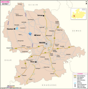
INDORE DISTRICT
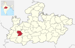
The Indore District is a district of Madhya Pradesh state in central India. The name of the district comes from the city of Indore, which is its administrative capital. This district forms part of the Indore Division.
As of 2011, it was the most populous of the 50 districts in Madhya Pradesh.
The Indore District has an area of 3,898 km²[4] and borders the districts of Ujjain to the north, Dewas to the east, Khargone (West Nimar) to the south, and Dhar to the west.
demographices
Indore is the most populous city in Madhya Pradesh. It is also the largest metropolitan city in Central India. According to the 2011 census of India, the population of Indore city (the area under the municipal corporation and outgrowths) was 1,994,397.[16] The population of the Indore metropolis (urban agglomeration that includes neighboring areas) was 2,170,295.[8] In 2011, the city had a population density of 25,170 people per square mile (9,718 per square km), rendering it the most densely populated of all the municipalities with population over 100,000 in Madhya Pradesh. As per the 2011 census, the city of Indore had an average literacy rate of 87.38%, higher than the national average of 74%. Male literacy was 91.84% and female literacy was 82.55%.[41] In Indore, 12.72% of the population is under 6 years of age. Indore’s Population has grown by 96,732 since 2015, which represents a 3.21% annual change. These population estimates and projections come from the latest revision of the UN World Urbanization Prospects which represents Urban agglomeration of Indore.
| Religions in Indore | ||||
|---|---|---|---|---|
| Religion | Percent | |||
| Hindus | 80.18% | |||
| Muslims | 14.09% | |||
| Jains | 3.25% | |||
| Others | 2.48% | |||
transport
TRAINS
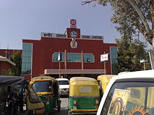
The Indore Junction is an A-1 grade railway station with a revenue of more than Rs. 500 million. The station comes under Ratlam Division of the Western Railways.
Electrification of the Indore–Dewas–Ujjain was completed in June 2012. Ratlam–Indore broad gauge conversion was completed in September 2014.[120] Indore–Mhow section was upgraded to broad gauge in 2016 and electrified in 2017.
BUS
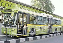
Indore’s City Bus transport system runs through 277 km (172 mi) of road with a daily ridership of over 140,000.[123] Atal Indore City Transport Services Ltd, a PPP scheme operates buses and radio taxis in the city. The buses designated as City Bus operate on 64 Routes[124] with a fleet of 361 buses, with 421 bus stops.[124] The buses are color-coded into three colors: Blue, Magenta and Orange according to their route.
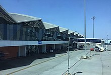
AIRPORT
Indore is served by Devi Ahilyabai Holkar International Airport, about 8 km from the city. It is the busiest airport in the state of Madhya Pradesh with 2,269,971 passengers and 10851 tons cargo for April 2017- March 2018. Devi Ahilyabai Holkar International Airport, Indore has been adjudged as the best airport in the under 2 million annual passenger footfall category in the Asia Pacific region in the Airports Council International (ACI)’s airport service quality (ASQ) rankings for the year 2017.
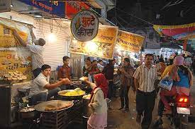
MARKET
Sarafa Bazaar (English: Sarafa Market) is a jewellery market and night street food court[1] located in central Indore, India. Sarafa is one of the market in India which remains as a jewellery marketplace at daytime and converts itself into a street food court at night.[2] The market consists of two sub-markets namely Bada Sarafa Bazaar and Chhota Sarafa Bazaar. Indore’s Sarafa Bazaar is a popular tourist place because of its cuisine and night lifestyle.
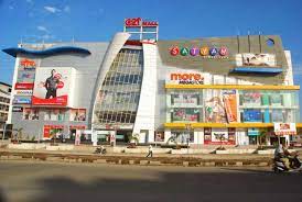
SHOPPING MALL
C21 Mall or Century 21 Mall is a shopping mall in the city of Indore in India. It’s the other half of the twin malls Malhar Mega & C21 located adjacent to each other in Vijay Nagar, Indore.[
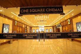
MOVIE THREATERS
Cine Square Cinemas – Airport Road is a popular theatre located at 2nd Floor, Space Tower, Near Surjeet Hyundai Showroom, Airport Road, West, Indore. Cine Square Cinemas – Airport Road has 1 screens. Movies now showing at Cine Square Cinemas – Airport Road are NONE. Facilities available at Cine Square Cinemas – Airport Road are Parking and Food And Beverage.
PARKS
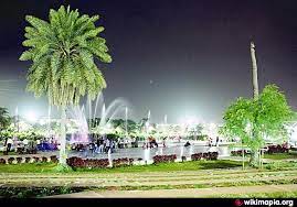
Regional Park Indore (officially Atal Bihari Vajpayee Regional Park) is a park located in Indore, Madhya Pradesh. The park was developed and created by Indore Development Authority and was opened in 2003. Park is located on 80 acres of land with 42 acres for lake and other 38 for other attractions. Park is named after former Prime Minister of India Atal Bihari Vajpayee.[1][2] There is also a canal, which covers the whole park starting from one point of the pond and ending at the other part. The bridges over canal with the mist fountain make one feel a special type of peace, mentally as well as physically.
HOSPITALS
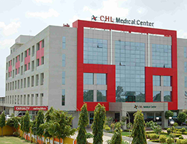
Convenient Hospitals Ltd. (CHL) Hospital, Indore is a hospital in Indore, India.
CHL is managed and owned by the Convenient Hospitals Ltd (CHL Group), Indore. The facility is a 225-bed multi-specialty critical care hospital located on A.B Road.
INDORE LOCAL AREAS
Rau Pithampur Road
Manglia
AB Road
Piplyahana
Mayakhedi
AB Bypass Road
Indore Bypass Road
Manik Bagh Road
Mahalaxmi Nagar
Vijay Nagar
Veer Sawarkar Nagar
Alok Nagar
Manbhavan Nagar
Vandana Nagar
Tilak Nagar
Telephone Nagar
Race Course Road
Ring Road
Shri Nagar Extension
Khandwa Road
Niranjanpur
Old Palasia
MOG Lines
Anoop Nagar
Kalindi Midtown
MR-10
Greater Brijeshwari Annexe
Rangwasa
Khajrana
Vaibhav Nagar
Rajwada
New Palasia
Vishnupuri Colony
Nihalpur Mandi
Agra-Bombay Bypass
Nipania
Sai Kripa Colony
Bengali Square
White Church Colony
MG Road
MR-11
Sula Khedi
Kalindi Kunj
Sarvsampanna Nagar
Bicholi Road
Manoraman Ganj
Rala mandal
Nainod
Mhow
Manishpuri
Sukliya
Joshi Guradiya
Shivnagar
Simrol
Super Corridor
Palakhedi
Bhicholi Mardana
Sneh Lata Ganj
Lokmanya Nagar
Hatod
Sarv Suvidha Nagar
South Tukoganj
Girdhar Nagar
Scheme No 54
Rajendra Nagar
Ujjain Road
Shivmoti Nagar
Krishi Mandi
Talawali Chanda
Rau-Dewas Bypass
Nagda
Maksi
Sarangpur
Pachore
Pardesi Pura
Datoda
Scheme 94
Jhalaria
Scheme 140
Panchderiya
Pipliya Kumar
DDU Nagar
Geeta Nagar
Shivaji Nagar
Vidur Nagar
Tulsi Nager
Indra Puri Colony
Nagar Nigam
Murai Mohalla
Azad Nagar
Tejpur Gadbadi
Dwarkapuri
Raj Mohalla
Dewas Naka
Goyal Vihar
Sadar Bazar
Dhar Road
Goyal Nagar
Gandhi Nagar
Jawahar Marg
Kalani Nagar
Smruti Nagar
Mari Mata Square
Scheme No 51
Limbodi
Vallabh Nagar
Bijalpur
Sudama Nagar
Silicon City
L I G Colony
Navlakha
Paraspar Nagar
Gumasta Nagar
Vaishali Nagar
Patni Pura
Anurag Nagar
Sanwer
Brijeshwari Annexe
Nanda Nagar
Musakhedi
Industrial Estate
Pithampur
Malhar Ganj
Lasudia Mori
Scheme No 71
Triveni Colony
Sanchar Nagar Main
Surya Dev Nagar
Rau
Bulandshahr
Palsikar Colony
Shri Ram Talawali
Subhash Nagar
Chhatribagh
New Rani Bagh
Ravi Shankar Shukla Nagar
Sangam Nagar
Depalpur
Silver Park Colony
Scheme No 114
Palda
Rambag
Jabran Colony
Chhoti Gwaltoli
Scheme No 103
Bhawrasla
Scheme No 134
Kamla Nagar
Bada Bangarda
Noorani Nagar
Krishnodaya Nagar
Anand Nagar
Chhavni
Dudhia
Sanvid Nagar
Hasalpur
Kordia Barda
Banganga
Pigdambar
Shramik Colony
Ambedkar Nagar
Kanadia road
Maharaja Tukoji Rao Holker Cloth Market
Barfani
Shri Ram Nagar
Lalaram Nagar
Rajmahal Colony
Gadi Adda
Indira Gandhi Nagar
Mirjapur
Paliya Haidar
Manavta Nagar
Harnya Khedi
Vindhyanchal Nagar
Morod
Panchvati Colony
Chhatrapati Nagar
Agrasen Nagar
Hathipala
Shripuram
Sapna Sangita Road
Shivampuri colony
Devguradia
Deoguradia
Bhatkhedi
Tirupati Nagar
WE HELP YOU TO SELL
PHONE
+91-7558348349
info@retailmarketing.co.in
ADDRESS
:- Shriram Niwas, 261, Bahirat Galli, Gaothan, Shivajinagar, Pune, Maharashtra 411005 :- infinity mall, Phase D, Shastri Nagar, Andheri West, Mumbai, Maharashtra 400047 :- Haware Fantasia Business Park, 47, near, Inorbit Bypass, Sector 30A, Vashi, Navi Mumbai, Maharashtra 400703